Text this colour is a link for Members only. Support us by becoming a Member for only £3 a month by joining our 'Buy Me A Coffee page'; Membership gives you access to all content and removes ads.
Text this colour links to Pages. Text this colour links to Family Trees. Place the mouse over images to see a larger image. Click on paintings to see the painter's Biography Page. Mouse over links for a preview. Move the mouse off the painting or link to close the popup.
Dorset Natural History and Archaeological Society is in Prehistory.
The Helstone [Map] on Ridge Hill, Portesham, By E. Cunnington, Esq.
Perhaops I may be permitted to say a few words in the first place as to the origin and composition of the many large rough stones, usually called Sarsens, around us at Portesham, and those following the stream down the valley to the sea. Professor Prestwich and other geologists consider them to be large masses of sand concreted together by a silicious cement. When the chalk stratum, now forming our highest hills, was at the bottom of the sea, beds of sands, clays, and gravels were deposited upon it ; when these were afterwards raised above the bed of the ocean they were denuded by the powerful action of seas, glaciers, and rivers, by which the main portion was carried away, leaving these blocks of sandy rock scattered about. In parts of Wiltshire their remains are very abundant ; they occupy for miles the bed of a valley near Clatford, Marlborough. Helstone, the name of the group of stones now before us, comes from either the Anglo-Saxon "hele," to hide or cover, or from "Hel," in Northern mythology the Goddess of the dead. Originally it was a long barrow, containing in its centre the nine stones supporting the large top or table-stone, 10½ft. long, by 6ft. broad, covering the usual interment. The lapse of many centuries has worn away the covering earth and exposed the stones to view as in many other instances. Hutchins gives us a picture of this dolmen, as I suppose it was in his time ; there it appears as perfect as a well-made mahogany table. The poor table came to grief entirely, but was re-instated as we now see it by the late Mr. Manfield, and I venture to think you will all agree that it is well done.
The next structure is a somewhat similar one, the Grey Mare and Colt, near Gorwell. This externally is a long barrow, 54 feet long, 25 feet broad, and about 5J feet elevation, covering the dolmen or stone-chamber within. Dolmen means a stone table from two Celtic words: "daul," a table, and "maen," a stone. It has been opened at each end ; at the south end are exposed the three megalithic uprights, and the top or table-stone ; each is about five to six feet high and two to three feet diameter. The total number of stones composing this dolmen is ten, as at the Helstone ; they consist of four conglomerates and six Sarsens. At the north end was apparently another interment with much smaller stones. Both of these chambered monuments date from the Stone Age. In France there are upwards of 3,000 ; some of these I had the pleasure of seeing in Brittany in 1883,
The most interesting and perfect is that of Gavr Innis [Map] in the Morbihan. The mound is 197 feet in diameter and 30 feet high; it is entered by a passage 44 feet long, leading into a chamber nine feet by eight feet. Both passage and chamber are lined by stones curiously sculptured with wavy, circular, and spiral lines. Probably the largest known of these dolmens is the one on the banks of the Boyne at New Grange, near Drogheda. It has a diameter of 316 feet, a height of 70 feet, with a passage 63 feet long, and many of the stones are there also sculptured with spirals and zig-zags. The gigantic monument is further distinguished by a circle of stones standing round it. These circles of stones were generally used to indicate places of interment, and consisted of large stones in the Stone Age, as we see at the AVinterbourne circle and also at that near Abbotsbury, not far from the Gorwell dolmen. These circles were smaller at a later date, as I found in opening a barrow on Mr. John Mayo's farm near Upwey (No. 4 on my plan of these barrows). This circle was hid under the turf and enclosed two Kistvaens with cremations in urns.
We have only time for a short notice of Stonehenge and Avebury temples, simply saying that Mr. Flinders Petrie writes as follows in his book on Tel-eMTesy or Lachish: — "This same peculiar dressing (of the Lachish Stones) is that of the stone work of the temple of Hagir Kim at Malta. This temple is called Phoenician, and what lends some support to this is that just the same system of stone tables, each on two blocks placed around the inside of the enclosure, is to be seen in the sacred enclosures of the villages in Philistia to this day. The same pock dressing is that of the wrought stones at Stonehenge, the best examples of it being on the flat tops of the uprights of the great trilithons."
Helstone [Map]. By E. Cunnington, Esq.
The earliest inhabitants of Britain were men living by the chase, using only stone weapons; the sole residue that we can recover are their cremated remains placed usually without any accompaniments under the nearest and easiest available material for a covering or barrow. The next in order would be the use of rough and badly-made baked urns for the cremation, llelstonc, the name of the group of stones now before us, comes from either the Anglo-Saxon hele, to hide or to cover, or from Hel, in northern mythology, the goddess of the dead. Originally this was a long barrow containing in its centre the nine stones supporting the large top or table-stone, 10 J, ft. long by 6ft. broad, covering the usual interment. The lapse of time has worn away the covering earth and exposed the stones to view as in many other instances. Hutch ins gives us a picture of this dolman as I suppose it was in his time ; he represents it to be as perfect as a well-made mahogany table. The poor table, like "Humpty Dumpty, had a great fall," and Manfield rebuilt it, nine stones and all. The grey mare and colt near Gorwcll is very similar, being a long barrow 54ft. long, 23ft. broad, and about 5ift. elevation, covering the dolman or stone-chamber within. Dolman means a stone table from two Celtic words — "daul" a table, and "maen" a stone. It has been opened, and at the south end are visible three of the megalithic uprights and tlie top or table-stone ; these are about 5ft. to 6ft high ami 2ft to 3ft. in diameter. The total number of stones composing this dolman is ten, as at the Helstone, four conglomerates and six sarsens.
The barrow opened last week — August 9th and 10th — by the permission of Mr. Manfield, is exactly 130ft. south-east of the Helstone: it has been cut away east and west to its present dimensions of 48ft. by 16ft., but was originally a round harrow of 48ft. diameter. Its height is about 6ft. At a depth of 5ft rather more than a cart load of large rough stones was found encircling an urn. This urn was resting on the original soil with a thin stone over its mouth and contained the burnt bones. It is 12in. in height, 8in. at the mouth, 9in. at its broadest diameter, and has an incised double zigzag ornamentation near the top enclosing diamond patterns. Two small scrapers and also a small rough celt were found and a small quantity of wood ashes.
In 1875 my attention was drawn to a spot about 100 yards to the north of Blagdon Monument — the Hardy Monument — where the gravel had been carted away, exposing a perpendicular section of a harrow. In the centre of this section a very black part clearly defined, led me to make an examination. The removal of this part disclosed a round pit of about 6ft. depth and 5ft diameter. The 2ft. at the base consisted of fine ashes with small pieces of charcoal ; the rest, a cairn of large stones. The stones have evidently been placed on the fire while it was burning, as they all had traces of the smoke of the fire. Two whetstones were found in the ashes with several flint flakes and two or three rough celts. The body was entirely consumed by the burning of the heather and gone, fresh fuel added, and then the stones heaped on the still burning fire.
I must not dwell on the Egyptian system of embalming or on their pyramids, dating back six thousand years, but would mention the Mausoleum built by Artemisia, wife of Mausolus, King of Caria, about B.C. 353 at Halicarnassus. This was considered one of the seven wonders of the world, and consisted of a basement 65ft. high, surmounted by a pyramid rising in steps to a similar height, on the apex of which stood a colossal group, about 1-tft. in height, of Mausolus and his wife in the quadriga. The tomb of Alyattes, King of Lydia, B.C. 618, is mentioned by Herodotus as one of the wonders of Lydia. It was north of Sardis, and consisted of a large mound of earth raised upon a foundation of great stones. On the top of it there were five pillars. Mr. Hamilton in his "Researches in Asia" says that it took him about ten minutes to ride round its base, which gave it a circumference of about a mile. The barrow raised over Hephcestion, the friend of Alexander the Great, cost 1,200 talents or about £232,000; this was B.C. 325 at Babylon.
In our own time the Lick Observatory on Mount Hamilton, California, is one of the most remarkable mausoleums. It was built by the desire of the American millionaire, James Lick, whose remains are in a vault within the foundation that support the great Telescope. He left 700,000 dollars for its erection.
All About History Books
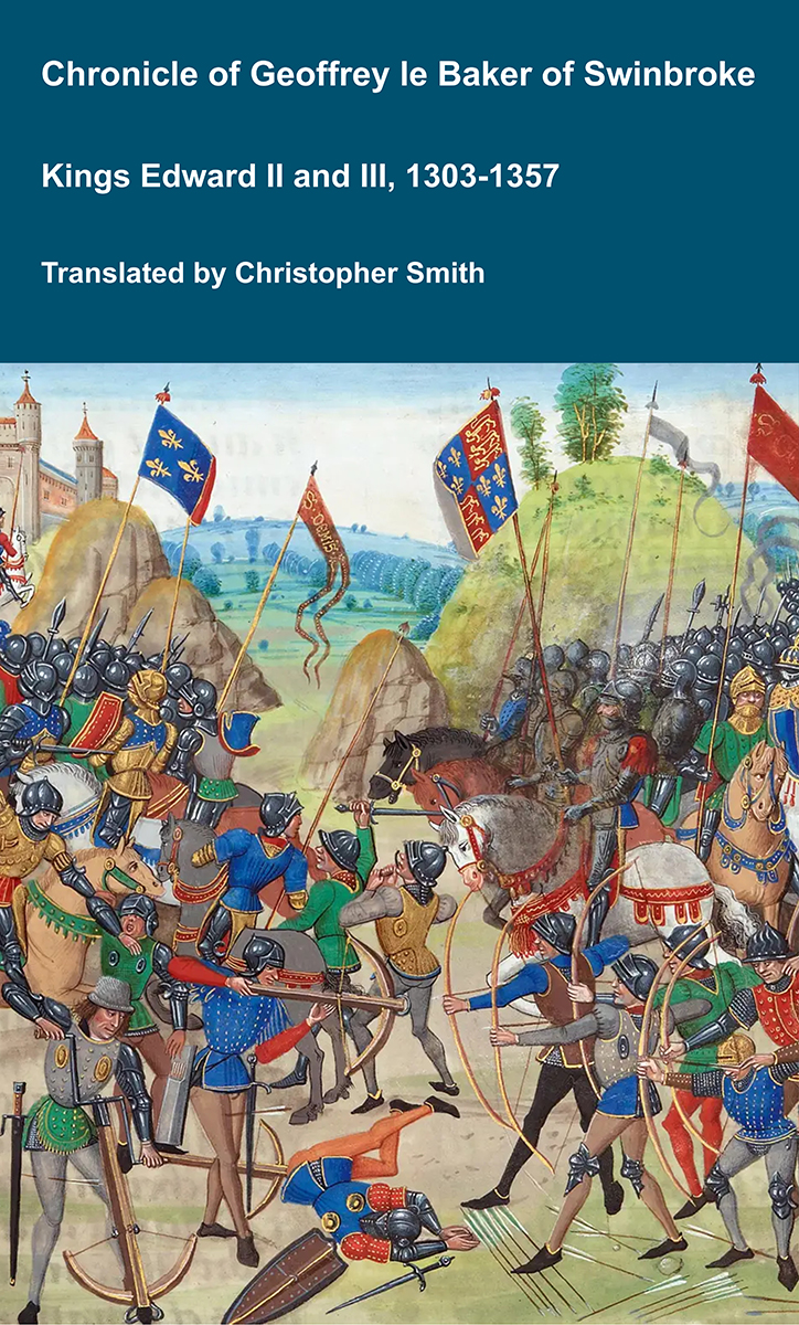
The Chronicle of Geoffrey le Baker of Swinbroke. Baker was a secular clerk from Swinbroke, now Swinbrook, an Oxfordshire village two miles east of Burford. His Chronicle describes the events of the period 1303-1356: Gaveston, Bannockburn, Boroughbridge, the murder of King Edward II, the Scottish Wars, Sluys, Crécy, the Black Death, Winchelsea and Poitiers. To quote Herbert Bruce 'it possesses a vigorous and characteristic style, and its value for particular events between 1303 and 1356 has been recognised by its editor and by subsequent writers'. The book provides remarkable detail about the events it describes. Baker's text has been augmented with hundreds of notes, including extracts from other contemporary chronicles, such as the Annales Londonienses, Annales Paulini, Murimuth, Lanercost, Avesbury, Guisborough and Froissart to enrich the reader's understanding. The translation takes as its source the 'Chronicon Galfridi le Baker de Swynebroke' published in 1889, edited by Edward Maunde Thompson. Available at Amazon in eBook and Paperback.
Besides the urn containing the calcined bones I exhibit a large diagram of an interment in a barrow at Friar Waddon, where two skeletons were laid side by side, but heads to feet, with at urn, apparently for food, at the head of each.

Dr. Colley March, addressing the party gathered round the rude stone structure, remarked that three names were applied to these stones, "Grey Wethers," Druid stones, and Sarsen stones. The term "Grey Wethers," of course, explained itself, for at a distance the stones did look like sheep on the hillside. Again, " Sarsen " was a simple term, a corruption of the word "Saracen," which at one time was employed to designate anything that was foreign. Geologists used the word "foreign stones" as country people used the word " Saracen," both meaning pretty much the same thing. But they were not all Druid stones. One would use the word "Druid" when it was a Saracen stone or Sarsen stone that had been employed by early man for any funerary purpose. Then what was the nature of Sarsen stones ? If they looked at the hill under Hardy's Monument, they would see two or three gravel pits. The gravel was all as loose as they pleased. It could be got out with the tap of a pick-axe. It consisted of pebbles intercalated with sand. That gravel once spread all over the chalk in that region, and in places the gravel became cemented with a silicious cement. They would observe that all the pieces of flint in a sarsen stone were rounded by the action of water, and they now and then saw other stones ; for instance, quartz. After the covering over of the chalk downs with this Tertiary gravel and sand, the chalk underneath it began to wear away through the infiltration of rain, and the surface became very uneven ; and so at Blagdon they could see how the gravel dipped and followed inclines down the sides of the hills ; and in doing that, however cemented it may have been, it was bound to break up into these great blocks, which remained scattered all over the face of the country. Many of them had been built into walls and broken up in various ways. And Neolithic men, whom people sometimes called "Druids," whenever they wanted to construct anything, used these great blocks or megaliths. The Ordnance Geological Survey map called these gravels Reading Beds ; but geologists like Mr. Clement Reid and Mr. Aubrey Strahan, the author of the Geological Memoir of Weymouth, 1898, considered that they were rather Bagshot Beds. To turn to the Helstone itself, it was sometimes called a cromlech and sometimes a dolmen. Throughout England they were generally called cromlechs ; but in Cornwall and Brittany dolmens. He himself preferred the word " dolmen," which meant " table stone or cap-stone." Charles Warne, in his "Ancient Dorset," published in 1872, speaking of the Helstone before its restoration, said (page 135) : "This cromlech stands on a gently-elevated mound. The supports of the capstone have sunk on the south-west side, and are virtually buried by it, its great weight being now chiefly sustained by a single prop on the north side, so that it rests in a greatly-inclined position. It measures more than ten feet in length, about seven feet in breadth, and has an average thickness of at least two feet and a-half. Originally it must have rested upon eight or ten supports. No doubt it was devoted to sepulchral purposes, and in its original state was probably covered with a mound of earth." It was generally believed, continued Dr. Colley March, that most of these dolmens were originally covered with a mound of earth, and so resembled tumuli. If so, of course the almost entire disappearance of the mound showed the great antiquity of the dolmen. But all dolmens were not covered with mounds of earth. He had seen some in Brittany, on the top of little conical hills, which could not by any possible human agency have ever been covered with a mound ; and those that were not covered with earth had some connection with the custom of dual interment. In his preface (page ii.) Mr. Warne said : "An attempt has been made to restore its ideal construction. Incredible as it may appear, the parties concerned seem to have thought it a meritorious act, for we find their names recorded in a note attached to a photograph of their great achievement:—
"We, the undersigned, a happy and obliged company, on the 11th June, 1866, desire to record our thanks and best wishes to Mr. and Mrs. Manfield, on occasion of the initiatory restoration of the Helstone, Portesham. — (Signed) Martin F. Tupper, J. V. W. Vandelour, John Nichols, H. de Beauvoir Tupper, Eobert Gambler Sweeting, John Bull, and W. K. Tupper."
![]() Become a Member via our 'Buy Me a Coffee' page to read complete text.
Become a Member via our 'Buy Me a Coffee' page to read complete text.
[As for the signatories to this curious and not unamusing record, Martin F. Tupper appears to be no other than the author of the "Proverbial Philosophy." He showed some interest in the relics of antiquity in Dorset, and in 1873 wrote some lines upon the "Union of Hearts " Roman tesselated floor unearthed on the site of Dorchester Prison.] Mr. Warne evidently did not like this " restoration; " but for himself, proceeded Dr. March, he was not sure that it was not a good thing to attempt to restore one such dolmen to a perfect condition in a district where there were so many imperfect.
The Hon. Treasurer enquired whether Dr. Colley March thought that perhaps "Helstone" was a name applied to the group from one menhir standing some way off, and forming the gnomon of an imaginary sundial, like the "Friar's Heel [Map]" at Stonehenge.
Dr. Colley March answered that he thought that the circle was called Helstone from the flat covering stone. "Hel " or "heel" still meant a covering. There was an expression "heeling potatoes," meaning to cover them in. In Devon, the covering slabs of a grave are called hellan-stones. As for the "Friar's Heel," that was the only stone at Stonehenge which had not been touched by tools — and many careful observers thought that it had been placed there since the building of Stonehenge, and that it had a memorial intention.

Notes on the Cromlech [Hellstone Burial Mound [Map]] at Portisham.
The Cromlech at Portishain (commonly called Possum) would seem to deserve more than the passing notice of a visit which was made by the Club on June 20, 1876. Therefore, as Miss Colfox has so kindly made drawings of this Cromlech, together with one by way of comparison at Morbihan, in Brittany, in presenting our readers with copies of these we propose to add a few notes upon these structures.
The Cromlech at Portisham, which rejoices in the name of the Hellstone, is situate upon an eminence to the north of the village, the foot of the hill being approached along the banks of a rivulet which runs through and over a picturesque mass of boulder stones, which, as they occur on the hills around the Cromlech in question and another in its vicinity, may doubtless have been derived from the heights above, having formerly belonged to that sandy deposit of the tertiary formation which rested on the chalk, and is perhaps of the same age as the grey wethers of Wiltshire, of which stones the ancient monument known as Avebury circles, and also some of the huge masses of Stonehenge, are formed.
It is likely then that the Cromlechs were formed from stones found handy for their purpose, and more especially when these occurred in commanding situations.
Much speculation has been hazarded as to the use and object of the Cromlech ; but all experience confirms the view that they were cementaries built to contain the remains, sometimes of a single individual, and at others of a whole family ; thus Mr' Lukis in his "Observations of the Primæval Antiquities of the Channel Islands" has the following remarks:
The Cromlechs. After the investigation of about twenty of these chambers of the dead, and examining their contents, the result has been convincing and satisfactory as to their original use, and they can no longer be considered otherwise than as ancient catacombs, erected by a remote people."1
It is interesting to note that the Cromlechs in the Channel Islands are evidently the same in kind, and were doubtless built by the same race of people to whom the Hellstone and the other Cromlechs of the county of Dorset are referred.
Note 1. The Archaeological Journal, Vol. 1, p. 146, 1845.
If we go further south we find in Brittany a repetition of the same kind of remains. Our engraving No. 2 is from a drawing kindly made by Miss Colfox, and has been described as follows:
"This Cromlech consists of a large rough stone placed hori- zontally on nine upright stones. It is from one of the fifty Isles of the Morbihan Brittany, and others abound in the neighbour- hood, several being still extant on this same little 'Ile aux Moines,' where there is also a circle of stones of considerable size. It is, like the Hellstone, placed on a high ridge commanding a fine view of the sea."1
The connection of our monument with the one figured from the Morbihan seems certain, and no less so with the like structures in the Channel Islands.
Note 1. Note by Mrs. Colfox, who so obligingly showed a fine collection of drawings of these structures on the visit of the Club to Bridport.
These facts seem all the more probable from the following remarks, also copied from Mr. Lukis's paper, before referred to:
"The grave, the churchyard, the dark cavern, and the lonoly cairn, still in our day continue to fill the mind of the ignorant with timid fears or apprehensions of evil. The 'heaped-up earth' and turf, which once lay over the covering stone of the Cromlech, having been long ago removed or levelled by time, these ancient depositaries of the dead have become exposed and left in detached portions, standing like giant spectres deprived of those accessories which completed their original form. Neglected throughout many generations, their once venerated site and hallowed use forgotten, their very name lost or doubtfully preserved amid the changes which the soil has undergone, they are left standing in solemn ruin, to the gaze of ignorant wonder, and the perplexity of the antiquary. Attracted by the magnitude of their dimensions and peculiar forms, our forefathers regarded them as the work of super-human agency. Their various names have thus become associated with fairies, hobgoblins, giants, and dwarfs, in all countries where they exist. The 'Cromlech,' or inclined stone, of Britain, the 'Grotte aux Fees,' 'La chambredu Diable' of the French, and the Celtic 'Ponquelaye' of these islands, all designate certain localities under elfin influence, and from which the vulgar mind is yet apt to recoil with feelings of superstition and dread. These terms are, however, significant; for they testify to that ignorance of their original use which followed the extinction of the race which, erected them. Those structures which have resisted the effects of time and remain entire owe their preservation in many instances to their remote distance from the haunts of man, or to that superstition which has in after ages paralyzed the hand of wanton destruction.
The names, 'Druid's Altar,' 'Temple des Druides' convey a definite meaning when applied to the Cromlech, properly so called, and probably owe their origin to the generally received opinion, and the incorrect translation of the word Cromlech, or inclined stone, affirmed by certain writers as disposed to permit the blood of the victims to flow from west to east! all which is mere conjecture and equally untenable. The more approximate derivation of the word, if ever it was originally applied to these structures, would be from the 'corum' (Breton), or 'cromen' (Welch), signifying a dome or vault — and 'lech,' a stone, or 'Ile.' a place or room (lieu, Fr.; locus, Lat.), or, as in these islands, 'pouque,' and 'large' or 'le' (from whence puck, an elf , or dwarf), meaning the place of the fairy."1
Note 1. Archæological Journal, Vol. 1, p. 144.
In considering the Hellstone, these notes become highly important, and more especially when compared with the remarks made at our meeting:
"Mr. Edwin Lees, president of the Worcester Naturalists Field Club, being seated on the top of the restored pile, was asked to say a few words about it. Mr. Lees said he had seen a great many of these Cromlechs, which, no doubt, go back to pre-historic times. Various opinions had been given by Archaeologists as to their original intention, but it is generally considered they were the burial places of some great chieftain or man of eminence. But besides that, he thought they were also places of divination — that some Druid, or person of divination, actually lived in this Cromlech, and that persons came to him and he offered them certain prophecies. But they were also consecrated to the worship of the goddess Hel, a female deity, to whom sanguinary sacrifices were made, and here, he had no doubt, on this altar such sacrifices had been offered. He believed these Cromlechs derived their names from the goddess, and these places got to be called Hail or Hel- stones. He found that in almost every county in England there were Helstones. There is a town in Cornwall called Helstone, and in Staffordshire there is a mound which bears the same name, and there is on it a monstrous impression which looks like the print of a man's fist, and it is said that the Devil struck the place with his fist, and the mark remains to this day. In Saxon times they became places where curses were disseminated. Some holy man lived under these stones, and if you wanted to pay an adversary out, instead of giving him a knock-down blow with your fist, you got the holy man to curse him ' in bed and in board, in living, in dying.' There were places in Wales were some old fellows will still go to their Cromlechs, and will undertake to curse for a man who has given them a fee for so doing, and it is believed that these curses take effect on goods, property, and person. The consequence was that a certain amount of superstition was attached to these Cromlechs. It was suggested that the name might also be derived from the word Hele (to conceal), as these Cromlechs covered graves."
![]() Become a Member via our 'Buy Me a Coffee' page to read complete text.
Become a Member via our 'Buy Me a Coffee' page to read complete text.
These notes are sufficient to show the interest attaching to monuments of this description. There are several of these in Dorset, and it will be well to collect all that is known about them before they pass away.
The Editor.
Fifth Interim Report on the Excavation at Maumbury Rings.
The Helstone [Map]. By Vere L. Oliver, F.S.A. (Read 16th September, 1920).
The Helstone is situated on Ridgehill, one of the spurs running up North to Blackdown from Portisham. It stands on a slight mound, which is more noticeable on the North side, but to the South there are only hollows, whence soil has evidently been removed. A held wall (older than 1803) runs across the mound North and South.
Hutchins, in his History of Dorset (1st edition), wrote, in 1774, that nearly all the upper stones were thrown down, the table-stone leaning on only one at the North, and that shepherds had dug a hole beneath it for a shelter. He gave a ridiculous plate of its supposed restoration, which looks like a round table on thick legs. In the 2nd edition, of 1803, an artistic illustration appeared showing the table-stone tilted and the existing held wall in the back-ground. What we now see may well be the remains of a long barrow which was placed N.W. and S.E. Hutchins stated that there was a terrace to to the N.W. leading to it 60ft. long, 30ft. broad at one end and 10ft. at the other; but the plough has obliterated all traces of this.

All About History Books
The Deeds of King Henry V, or in Latin Henrici Quinti, Angliæ Regis, Gesta, is a first-hand account of the Agincourt Campaign, and subsequent events to his death in 1422. The author of the first part was a Chaplain in King Henry's retinue who was present from King Henry's departure at Southampton in 1415, at the siege of Harfleur, the battle of Agincourt, and the celebrations on King Henry's return to London. The second part, by another writer, relates the events that took place including the negotiations at Troye, Henry's marriage and his death in 1422.
Available at Amazon as eBook or Paperback.
The Helstone is a Neolithic dolmen consisting of nine menhirs about 6ft. high out of the ground, surmounted by a cap or table-stone 10½ft. long, 6ft. wide and 2½. thick all rough natural sarsens devoid of tool marks. Hutchins stated that the under part of the table-stone seemed roughly chiseled; but I cannot see any tool marks, not even of stone hammers. The gentlemen who restored or rather rebuilt the dolmen have not I think rerixed the uprights as they should have been; for it was customary when one of the surfaces of a stone was fairly flat to place that side inwards, but some of these have been re-fixed edgeways like a slice of cake.
As this dolmen has been already described in three articles in our Proceedings I shall briefly recapitulate the various points raised.
The 1st article by the then editor, the late Professor Buckman, appeared in 18781. It was accompanied by a rough illustration together with that of a similar one in the Morbihan for comparison. He stated that the stones were derived from the local sandstone of the tertiary formation, and pointed the resemblance to dolmens in the Channel Islands. A very excellent illustrated article in Archæologia, Vol. LV, on dolmens in Japan, proves that they also resemble ours.
At Long Bridy there is a very large menhir 10ft. high, called Hell-stone; there is another near Cerne; and a town in Cornwall (Helston) bears the same name. It has been thought that such stones were dedicated to "Hell" the goddess of the dead. Others derive the name from A.S. Hele, to cover, or from Halig, holy.
The 2nd article by the late Mr. E. Cunnington appeared in 1893,2 and he was of the opinion that this had been a long barrow. The dolmen was rebuilt by the late Mr. Manfield about 1866.
The 3rd description, printed in 1908, was by the late Dr. Colley March, t and was illustrated.
Note 1. D.F.C. Proceedings, Vol. II, 104.
Note 2. Ibid, Vols. XV. 52-54; XVI, 175-177.
Note 3. Ibid, Vol. XXIX. pp. Ixxv-lxxviii.
![]() Become a Member via our 'Buy Me a Coffee' page to read complete text.
Become a Member via our 'Buy Me a Coffee' page to read complete text.
The word Dolmen is derived from two Celtic words daul a table and maen a stone, but the French nomenclature is I think preferable. They define menhir as an unfashioned upright stone; lech as a dressed menhir; cromlech as a group of menhirs in a circle; and dolmen as a chamber formed by menhirs covered by table stones, often approached by a gallery and usually covered by earth.
The Helstone, as we now see it, is therefore not in its original state ; but Dr. Colley March thought that its restoration was satisfactory, as it is the only complete one in the county. When such stones have become dislodged within recent times, as in the case of Stonehenge, it has been considered permissible to re-instate them, otherwise it would be injudicious to interfere with them.
Dolmens were usually covered over with earth, constituting a chambered long barrow, such as this and the one at Gorwell two miles away ; but occasionally they were intended to stand free or uncovered as in France. In our example the stones do not occupy a prominent site, and I believe they were originally covered. In that case the interstices between the uprights were filled in with rough walling, to keep back the soil. The numbers 9 and 3, often used for grouping the menhirs, have a mystic meaning. Long barrows may be simple or chambered, sometimes with an external dolmen, and enclosed by a peristalith of menhirs.
There are no circular chambered barrows in England, but there are elsewhere.
Dr. Thurnam estimated that there were 60 long barrows in Wilts1; and as there were 2,000 barrows of all sorts, he calculated that they averaged one long barrow to 35 round ones. He stated that Dorset contained only 12 long ones, mostly to the North towards Wilts. They were also found in Gloucestershire, Somerset and Hants (13 examples, Dr. W. F.), but very rarely in the rest of England. They were invariably isolated, quite two or three miles apart, from 100ft. to 400ft. long, by 30ft. to 50ft. wide, of moderate height, with a trench along the sides, but not at the ends in fact pear-shaped usually lying east and west, the chambered east end being wider and higher; but one in six lie north and south. They were always associated with giants by local tradition, and that name often survives as a place name. A very interesting account of a chambered long barrow opened in Somerset in 1909 may be seen in a little book " Records by Spade and Terrier " by the Rev. J. Wickham. Canon Greenwell describes 13 which he opened in Yorkshire; but the most complete excavation ever made was that of Worbarrow on Handley Down by the late General Pitt- Rivers.
Note 1. Archæologia, Vol. XLII.
![]() Become a Member via our 'Buy Me a Coffee' page to read complete text.
Become a Member via our 'Buy Me a Coffee' page to read complete text.
Chambered ones naturally occur more frequently in stone districts, sarsens being often utilised for their construction; but at Worbarrow, in North Dorset, there were traces of wooden supports. The plan varies, the simple ones having a passage leading to an inner chamber, sometimes divided into several cells. No sculpture is found as in Scotland, Ireland and Brittany, no metal, and as a rule no sign of cremation. Leaf flint arrow-heads and scrapers, bone implements, and a little coarse pottery, with bones of animals, such as deer, wild boar and cattle, are occasionally found. The numerous skeletons lie in a contracted position, but human bones are often found piled up promiscuously, possibly from the chamber having been used as an ossuary, or this may be due to rifling by treasure hunters.
Skulls (dolichocephalic) are the important factor, for, taking the length as 100, they average a breadth index of 69, much longer and narrower than any present race in Europe. The height of these men was not more than 5ft. 4ins., often less than 5ft. The Iberian type still to be noticed in the West of France, Spain, Portugal, Ireland and Wales, is supposed to have descended from the builders of Avebury and the long barrows.
The finest dolmens (3,000) are in France; but England is noted for its great circles, such as Avebury and Stonehenge.
In the Morbihan in Brittany, there are huge chambered tumuli, some with many carved stones. I had the pleasure of visiting them and also Carnac in 1914, with a few Salisbury friends, under the guidance of Mr. Doran Webb.
The long-headed race was undoubtedly the older, and must have been conquered and absorbed by the round-headed (brachycephalic) Bronze Age man, for long skulls may be also found in round barrows, but never round ones in long barrows.
As to the origin of these barrow builders: Tumuli are to be seen in North Africa, especially Algeria, and West Asia beyond the Jordan. There is then a gap of 2,000 miles to India, and further east they occur in Burmah and Japan. In the steppes, North of Circassia, there are hundreds of thousands near the home of the Aryans whence they may have spread to the Baltic, but it is uncertain if Asia or Africa was the cradle of the race or cult. There are no dolmens in the Valley of the Nile, in Phoenicia, or its colonies. There is no record of any great migration; so it may be that a certain religion spread to many races across the world.
In Europe they are diffused over the Western side only, where they mark the course of prehistoric commerce, which skirted the shores of Africa as far as the Atlantic, and after passing along the coasts of Spain, Portugal, and France, ended at the British Isles. Another commercial route passed through Italy, the Islands of Sardinia and Corsica, across France and Brittany, to the English Channel.
The movement was probably from the Aegean to the North, rather than from Scandinavia to the South. The tombs of New Grange in Ireland resemble those of Crete and Mycenae in Greece.
![]() Become a Member via our 'Buy Me a Coffee' page to read complete text.
Become a Member via our 'Buy Me a Coffee' page to read complete text.
The last period of the Neolithic Age in Italy may be fixed at about 4,000 B.C., but stone tools may have been used in the North centuries after the introduction of copper or bronze in the South. No fixed dates are possible, for there was much overlapping, and authorities disagree; but by studying sections of ancient sites, such as in Crete, approximate dates are obtainable. Pottery is also an invaluable guide in estimating the progress of Neolithic civilisation. Its decoration was first made with the thumb and finger nails, and there was an absence of curvilinear design.
Parallel lines, zigzags, striated triangles and dotted patterns abound. Later the incised lines on black ware were filled with a white substance; and colours and even slip work were introduced. Drinking cups, incense holders, urns, with clay figures of women, animals and birds, were made.
The Neolithic occupation of Knossos, in Crete, covered more than 3,000 years, and supplies dates for the rest of Europe, the whole period lasting perhaps 7,000 years.
The incised axes on certain stones in the Morbihan tumuli represent votive ones, and were a cuitus object and symbol of divinity. There are menhirs in France and Sardinia which apply to the mother goddess of nature and are a link with the East. It is noteworthy that paleolithic ivory female figures have been discovered in France far superior to anything neolithic. And the study of all these prehistoric remains leads one to realise that our predecessors of the stone age were possessed of considerable skill and artistic talent with which they had not been usually credited.
We are fortunate to possess, in this neighbouthood, this dolmen, also a chambered long barrow and a cromlech. The downs about here are so crowded with barrows and megalithic remains as to constitute a veritable Mecca of the Neolithic and Bronze Ages. The Bronze Age barrow 45 yards S.E. was opened by Mr. Cunnington in 1894 and contained an urn of burnt bones with a stone covering its mouth resting on the undisturbed soil.1 There are several large stones lying about, one of which especially seems to resemble a menhir.
Note 1. D.F.C. Proceedings, Vol. XXXVII, p. 47.
![]() Become a Member via our 'Buy Me a Coffee' page to read complete text.
Become a Member via our 'Buy Me a Coffee' page to read complete text.