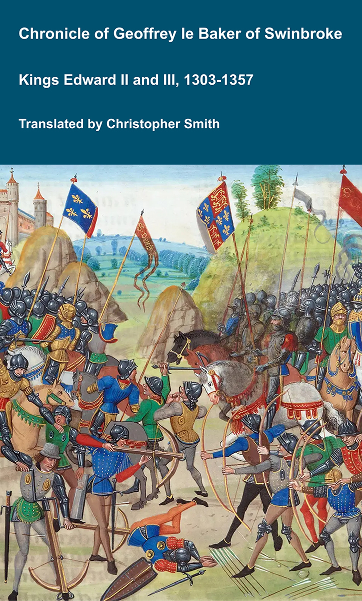
Chronicle of Geoffrey le Baker of Swinbroke
Baker was a secular clerk from Swinbroke, now Swinbrook, an Oxfordshire village two miles east of Burford. His Chronicle describes the events of the period 1303-1356: Gaveston, Bannockburn, Boroughbridge, the murder of King Edward II, the Scottish Wars, Sluys, Crécy, the Black Death, Winchelsea and Poitiers. To quote Herbert Bruce 'it possesses a vigorous and characteristic style, and its value for particular events between 1303 and 1356 has been recognised by its editor and by subsequent writers'. The book provides remarkable detail about the events it describes. Baker's text has been augmented with hundreds of notes, including extracts from other contemporary chronicles, such as the Annales Londonienses, Annales Paulini, Murimuth, Lanercost, Avesbury, Guisborough and Froissart to enrich the reader's understanding. The translation takes as its source the 'Chronicon Galfridi le Baker de Swynebroke' published in 1889, edited by Edward Maunde Thompson.
Available at Amazon in eBook and Paperback format.
Cirencester, Gloucestershire is in Gloucestershire.
Fosse Way Cirencester. In Corinium Dobunnorum [Map] aka Cirencester the Fosse Way follows the Old Tetbury Road [Map] and Castle Street [Map] as far as the Market Place [Map] where it gives way to the East-West Silchester to Gloucester road following Cricklade Street [Map], Lewis Lane [Map] and London Road [Map] before reaching the Burford Road [Map].
Fosse Way. After Batheaston the Fosse Way continues along Bannerdown Road [Map] where it curves around Solsbury Hill, Somerset [Map] to reach the high ground where the road straightens out passing Three Shires Stone [Map], Fosse Gate, Wiltshire [Map], crossing the Gloucestershire River Avon 1.2km south-west of Easton Grey [Map] before reaching the Cotswold Airport, Gloucestershire [Map] after which it travels to Corinium Dobunnorum [Map] aka Cirencester.
Ermine Street 41b travels from Speen, Newbury [Map] through Baydon, Wiltshire [Map], Wanborough, Wiltshire [Map], Blunsdon St Andrew, Wiltshire [Map] to Cirencester, Gloucestershire [Map]. Whilst Margery's scheme doesn't say so, the road appears to continues from Cirencester, Gloucestershire [Map] to Gloucester [Map].
Fosse Way 5d Cirencester to High Cross. From Corinium Dobunnorum [Map] aka Cirencester the Fosse Way continues straight through Fossbridge, Gloucestershire [Map] where it crosses the River Coln, then past Northleach [Map] where it crosses the modern A40, then past Bourton-on-the-Water [Map] after which Icknield Street continues towards Alcester, Warwickshire [Map] and Lichfield, Staffordshire [Map]. 4.5km after Bourton-on-the-Water the Fosse Way makes a change in direction heading north passing through Stow-on-the-Wold, Gloucestershire [Map], Moreton-in-Marsh, Gloucestershire [Map], Halford, Warwickshire [Map], past Fosse Way, Compton Verney [Map], Princethorpe, Warwickshire [Map], then Bretford, Warwickshire [Map] where it crosses the Warwickshire River Avon. After it crosses the River Avon it continues straight to Venonae [Map] aka High Cross where it crossed Watling Street.
In 577 Ceawlin King Wessex and his son Cuthwine [aged 12] won a major victory over the Britons at the Battle of Dyrham at Hinton Hill Dyrham, Gloucestershire. The victory of resulted in the capture of Gloucester [Map], Cirencester, Gloucestershire [Map] and Bath, Somerset [Map].
Coinmail Briton, Condidan Briton and Farinmail Briton were killed.
Assers Life of Alfred 57. 879. 57. The Danes go to Cirencester.133 In the year of our Lord's incarnation 879, which was the thirty-first of King Alfred's life, the aforesaid army of heathen, leaving Chippenham, as they had promised, went to Cirencester [Map], which is called in Welsh Cairceri, and is situated in the southern part of the kingdom of the Hwicce134, and there they remained one year.
Note 133. Chiefly from the Chronicle.
Note 134. Gloucester, Worcester, etc.
Anglo-Saxon Chronicle. 879. This year went the army from Chippenham [Map] to Cirencester [Map], and sat there a year. The same year assembled a band of pirates, and sat at Fulham [Map] by the Thames. The same year also the sun was eclipsed one hour of the day.
Anglo-Saxon Chronicle. 1020. This year came King Knute [aged 25] back to England; and there was at Easter a great council at Cirencester, Gloucestershire [Map], where Alderman Ethelward was outlawed, and Edwy, king of the churls. This year went the king to Assingdon; with Earl Thurkyll, and Archbishop Wulfstan, and other bishops, and also abbots, and many monks with them; and he ordered to be built there a minster of stone and lime, for the souls of the men who were there slain, and gave it to his own priest, whose name was Stigand; and they consecrated the minster at Assingdon. And Ethelnoth the monk, who had been dean at Christ's church, was the same year on the ides of November consecrated Bishop of Christ's church by Archbishop Wulfstan.
On 7th January 1400 at Cirencester, Gloucestershire [Map] Ralph Lumley 1st Baron Lumley [aged 40] was beheaded by the townspeople following an unsuccessful attempt to seize the town. Baron Lumley forfeit.
Thomas Holland 1st Duke Surrey [aged 26] was beheaded. He had to forfeit the honours and estates he had gained after the arrests of Gloucester and Arundel: Duke Surrey extinct. He retained those he had received before: His brother Edmund [aged 16] succeeded 4th Earl Kent, 3rd Baron Holand, 8th Baron Wake of Liddell. He was buried, or re-buried, at his foundation Mount Grace Priory, North Yorkshire [Map].
John Montagu 3rd Earl Salisbury [aged 50] was captured, tried and beheaded. Earl Salisbury, Baron Montagu, Baron Montagu, Baron Monthermer forfeit.
Bernard Brocas [aged 46] was captured.
On 4th February 1400 Bernard Brocas [aged 46] was tried, and condemned to death, by Thomas Fitzalan 10th Earl of Surrey 5th or 12th Earl of Arundel [aged 18] at Tower of London [Map] for his role in the Epiphany Rising having been captured in Cirencester, Gloucestershire [Map].
On 5th February 1400 Bernard Brocas was beheaded at Tyburn [Map]. He was buried at Greyfriars Church Farringdon Within [Map].
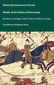
The Deeds of the Dukes of Normandy
The Gesta Normannorum Ducum [The Deeds of the Dukes of Normandy] is a landmark medieval chronicle tracing the rise and fall of the Norman dynasty from its early roots through the pivotal events surrounding the Norman Conquest of England. Originally penned in Latin by the monk William of Jumièges shortly before 1060 and later expanded at the behest of William the Conqueror, the work chronicles the deeds, politics, battles, and leadership of the Norman dukes, especially William’s own claim to the English throne. The narrative combines earlier historical sources with firsthand information and oral testimony to present an authoritative account of Normandy’s transformation from a Viking settlement into one of medieval Europe’s most powerful realms. William’s history emphasizes the legitimacy, military prowess, and governance of the Norman line, framing their expansion, including the conquest of England, as both divinely sanctioned and noble in purpose. Later chroniclers such as Orderic Vitalis and Robert of Torigni continued the history, extending the coverage into the 12th century, providing broader context on ducal rule and its impact. Today this classic work remains a foundational source for understanding Norman identity, medieval statesmanship, and the historical forces that reshaped England and Western Europe between 800AD and 1100AD.
Available at Amazon in eBook and Paperback format.
Before 1472 Bishop Thomas Ruthall was born at Cirencester, Gloucestershire [Map]. The date being based on his being ordained Deacon at age eighteen or over.
On 13th April 1477 Ankarette Hawkeston aka Twynyho taken to Cirencester, Gloucestershire [Map].
On 14th April 1556 Anthony Kingston [aged 48] died at Cirencester, Gloucestershire [Map]. Possibly suicide. he had been implicated in the Dudley Consipracy and was on his way from Gloucester to London when he died.
John Evelyn's Diary. 20th May 1639. Accompanied with one Mr. J. Crafford (who afterward being my fellow-traveler in Italy, there changed his religion), I took a journey of pleasure to see the Somersetshire baths [Map], Bristol, Gloucestershire [Map], Cirencester, Gloucestershire [Map], Malmesbury, Wiltshire [Map], Abington, and divers other towns of lesser note; and returned the 25th.
Fosse Way Cirencester. In Corinium Dobunnorum [Map] aka Cirencester the Fosse Way follows the Old Tetbury Road [Map] and Castle Street [Map] as far as the Market Place [Map] where it gives way to the East-West Silchester to Gloucester road following Cricklade Street [Map], Lewis Lane [Map] and London Road [Map] before reaching the Burford Road [Map].
Fosse Way Cirencester. In Corinium Dobunnorum [Map] aka Cirencester the Fosse Way follows the Old Tetbury Road [Map] and Castle Street [Map] as far as the Market Place [Map] where it gives way to the East-West Silchester to Gloucester road following Cricklade Street [Map], Lewis Lane [Map] and London Road [Map] before reaching the Burford Road [Map].
Fosse Way Cirencester. In Corinium Dobunnorum [Map] aka Cirencester the Fosse Way follows the Old Tetbury Road [Map] and Castle Street [Map] as far as the Market Place [Map] where it gives way to the East-West Silchester to Gloucester road following Cricklade Street [Map], Lewis Lane [Map] and London Road [Map] before reaching the Burford Road [Map].
Fosse Way Cirencester. In Corinium Dobunnorum [Map] aka Cirencester the Fosse Way follows the Old Tetbury Road [Map] and Castle Street [Map] as far as the Market Place [Map] where it gives way to the East-West Silchester to Gloucester road following Cricklade Street [Map], Lewis Lane [Map] and London Road [Map] before reaching the Burford Road [Map].
Fosse Way Cirencester. In Corinium Dobunnorum [Map] aka Cirencester the Fosse Way follows the Old Tetbury Road [Map] and Castle Street [Map] as far as the Market Place [Map] where it gives way to the East-West Silchester to Gloucester road following Cricklade Street [Map], Lewis Lane [Map] and London Road [Map] before reaching the Burford Road [Map].
Fosse Way Cirencester. In Corinium Dobunnorum [Map] aka Cirencester the Fosse Way follows the Old Tetbury Road [Map] and Castle Street [Map] as far as the Market Place [Map] where it gives way to the East-West Silchester to Gloucester road following Cricklade Street [Map], Lewis Lane [Map] and London Road [Map] before reaching the Burford Road [Map].

On 6th August 1794 Henry Bathurst 2nd Earl Bathurst [aged 80] died at Oakley Grove Cirencester, Gloucestershire. His son Henry [aged 32] succeeded 3rd Earl Bathurst of Bathurst in Sussex, 3rd Baron Bathurst. Georgiana Lennox Countess Bathurst [aged 28] by marriage Countess Bathurst of Bathurst in Sussex.
On 25th May 1866 Henry George Bathurst 4th Earl Bathurst [aged 76] died at Oakley Grove Cirencester, Gloucestershire. His brother William [aged 75] succeeded 5th Earl Bathurst of Bathurst in Sussex, 5th Baron Bathurst.
Fosse Way Cirencester. In Corinium Dobunnorum [Map] aka Cirencester the Fosse Way follows the Old Tetbury Road [Map] and Castle Street [Map] as far as the Market Place [Map] where it gives way to the East-West Silchester to Gloucester road following Cricklade Street [Map], Lewis Lane [Map] and London Road [Map] before reaching the Burford Road [Map].
Quern's Barrow is also in Cotswolds Neolithic Tombs.
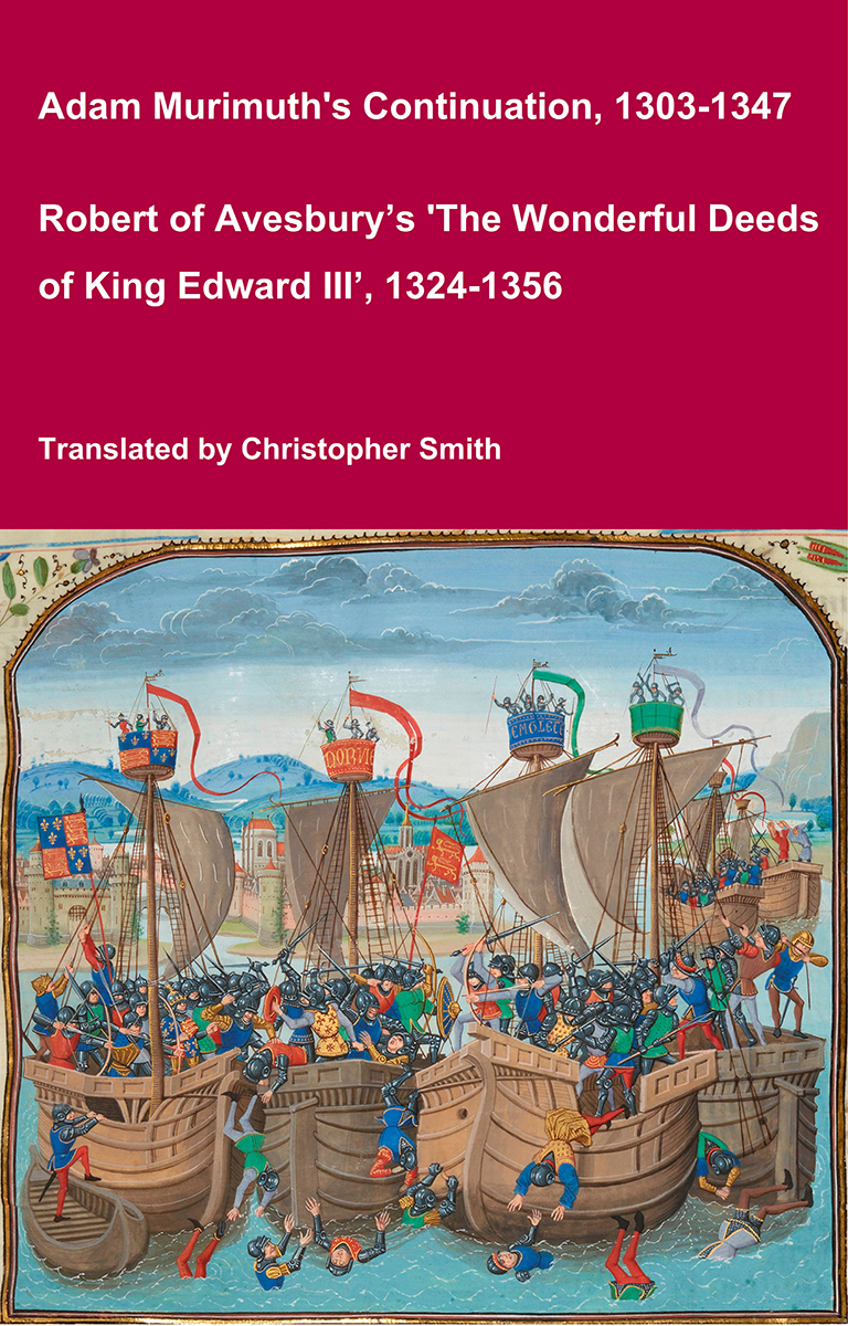
Adam Murimuth's Continuation and Robert of Avesbury’s 'The Wonderful Deeds of King Edward III'
This volume brings together two of the most important contemporary chronicles for the reign of Edward III and the opening phases of the Hundred Years’ War. Written in Latin by English clerical observers, these texts provide a vivid and authoritative window into the political, diplomatic, and military history of fourteenth-century England and its continental ambitions. Adam Murimuth Continuatio's Chronicarum continues an earlier chronicle into the mid-fourteenth century, offering concise but valuable notices on royal policy, foreign relations, and ecclesiastical affairs. Its annalistic structure makes it especially useful for establishing chronology and tracing the development of events year by year. Complementing it, Robert of Avesbury’s De gestis mirabilibus regis Edwardi tertii is a rich documentary chronicle preserving letters, treaties, and official records alongside narrative passages. It is an indispensable source for understanding Edward III’s claim to the French crown, the conduct of war, and the mechanisms of medieval diplomacy. Together, these works offer scholars, students, and enthusiasts a reliable and unembellished account of a transformative period in English and European history. Essential for anyone interested in medieval chronicles, the Hundred Years’ War, or the reign of Edward III.
Available at Amazon in eBook and Paperback format.
Archæological Handbook of Gloucestershire. Cirencester aka Quern's Barrow [Map]
There is a long barrow in the "Querns" field, close to the Cirencester Railway Station, on the south-west of the town; its length is about 180 feet. It was opened thirty years ago by Messrs. Newmarch and Buckman, and is mentioned by them in their "Remains of Roman Art in Cirencester." It is there suggested that the word "querns" is derived from "cairn," or burial place. The Roman amphitheatre lies a little to the south-east of the barrow. Several skeletons were found arranged east and west, but it seems they were in a very fragmentary state, none of them being in a condition to be capable of measurement. The explorations consisted simply of two transverse cuts through the mound, so that it is impossible to say what may yet be found.
See Buckman's "Corinium" p12.
Long Barrows of the Cotswolds. Quern's Barrow [Map]
Gloucestershire, 51 S.W. Parish of Cirencester. 46 *.
Latitude 51° 42' 44". Longitude 1° 58' 19". Height above O.D. about 400 feet.
Situated in a field called " The Querns"1 N.E. of the " Bull-ring" and S.W. of the station. About 180 feet long. Opened " about 30 years ago by Messrs. Newmarch and Buckman, and mentioned by them in their Remains of Roman Art in Cirencester . . Several skeletons were found arranged E. and W., but it seems they were in a very fragmentary state, none of them being in a condition to be capable of measurement. The explorations consisted simply of two transverse cuts through the mound."
Visited December 24th, 1920. The steepest slope is on the N. side of the barrow, which is widest at the east end and highest now zt the west end. There are no signs of any excavations, which must have been filled in, a most unusual procedure in those days.
W. 8.
Buckman, Corinium, p. 12.
Note 1. In the year 1292 the name of this piece of ground was spelt CRONDLES or CRONNES (Trans. B. and G.A.S. IX. 1884-5, P. 321). The first spelling clearly goes back to O.E. Crundel. The second part of the word means a pit or quarry, and is still used in Hampshire to describe old chalk-pits ('dells'). The first part seems connected with 'crown/ May the whole word have meant originally a quarry from which quern-stones were got? This meaning would of course be inapplicable to a chalk district, but the original meaning might have become lost there. The change from cron to quern undoubtedly took place at Cirencester, whether my suggested explanation is correct or not. I do not know whether the oolite here was used for, or suitable for, grinding-stones, or whether there is any record of their manufacture here. The shape of the Romano-British circular quern is strongly suggestive of a crown.